|
Complex 10 |
 |
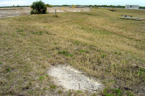
We are facing roughly southeast. The concrete pad in front of us is the
former location of Complex 10. The Complex 10 launch area was demolished in 1959
to make way for Complex 31, Pad A. The building at the the top right of the photo
is the optical alignment building for Complex 31, and did not exist when Complex
10 was in use.
On the ground, we can see the remains of the underground cable
tray that once ran from the Complex 9/10 blockhouse to the Complex 10 launch
area.
|
|
Photo courtesy of Steve Sanders
Mission Flight Control Officer, CCAFS
|
',441,291))