| Complex 34 aerial view |
| Complex 34 aerial view |
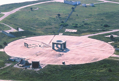
Here is an aerial view of Complex 34. Standing prominently in the center of the 430 foot diameter launch pad is the launch pedestal. Immediately to its left is all that remains of the ECS (Environmental Control System) building.
Toward the bottom of the launch pad (at roughly the 7 o'clock position) are the blast deflectors. Immediately to their left is the automatic ground control station.
Just outside of the launch pad (at roughly the 10 o'clock position) is a revetment. This is the remains of the GN2 high-pressure gas facility (a similar facility also existed on the opposite side of the launch pad). Together, these facilities stored the high-pressure gases (helium and nitrogen) required by launch vehicles.
At the extreme top of the photo, slightly right of center, is the fuel storage area. This facility housed twin 30,000 gallon tanks for storing RP-1 (kerosene fuel), and the associated transfer equipment (pumps, plumbing, etc.). The line you see leading from the facility to the launch pad is actually a row of concrete supports for the fuel lines.
The road out from the launch pad at approximately the 2
o'clock position leads to the liquid oxygen storage area, where two LOX tanks once stood.
|
Photo Copyright © 1999 Joe Marino/Aerospace Reports Photographic Services. Joe is a staff photographer for the National Space Society. |
| Tour home | CCAFS map | Website map |